“Road Trip through History” by Lynn Marie Allen
It never ceases to amaze me how quickly circumstances can change or reroute perhaps the fabric of existence. As each of you heads into the upcoming week, giving thanks and celebrating with your families, I hope your holiday is profoundly blessed. Recently, having been asked to explore towns that are no longer present. Eluding a little, this will lead to future and further exploration. In looking at now lost and forgotten towns of Brown County, Kansas, I discovered around thirtyish towns that have been erased by time. Remember, many of these towns were established initially by settlers looking for a piece of the “land of plenty.”
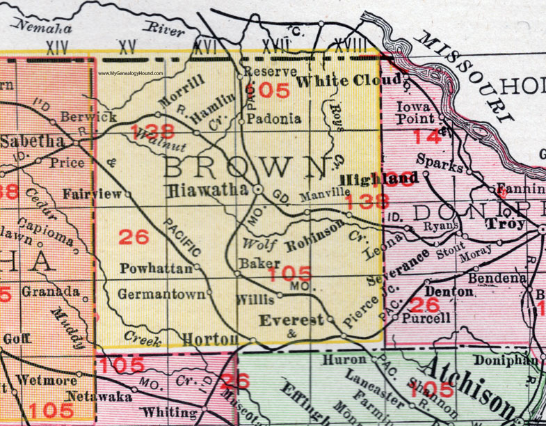
Baker, now nearly erased by time. Once upon a time, in a not-so-distant time ago, Baker was a bustling town. Complete with a train depot, a grocery store, and a school, which also stood as the community center. Baker and all the beautiful pieces of history have nearly been erased from the maps. Baker, Kansas, was established in Brown County, Kansas, in 1882, and by 1933, the town of Baker was rerouted into ghost town history. Baker was established by the Missouri Pacific Railroad in 1882. People once hopped on board for Kansas City at the Depot in Baker, Kansas, for a delightful time in the city to return home at the end of their excursion home. Baker was located approximately 7 ½ miles south of Hiawatha. The town of Baker was named in honor of Colonel A.C. Baker, an early settler and a Civil War veteran.
Carson, Kansas, was established in 1857 and erased by 1898. I was once holding the county seat of Brown County for a brief period of about four months. D. McFarland and others in 1856 established the township. The township’s original name was changed from Sawin’s Store to Carson in 1857. Carson was the first post office in Walnut Township, and M. L. Swain was the first postmaster. Carson is located 5 miles West of Hiawatha. Carson was named after William Carson, a Civil War veteran and prominent citizen who operated a mercantile and served as postmaster fo the town for many years.
Claytonville, Kansas, was established in November 1856 and erased by 1882. Claytonville held the county seat of Brown County for a brief period. George E. Clayton laid out the township at a generous 320 acres, attracting 15 families and a store. G. E. Clayton established the store in August 1857. No city officers were elected. The town site, now forgotten, has become farmland. Claytonville was located eight miles south and one mile east of Hiawatha. The town was named after John Clayton, a prominent figure in the establishment of the town and businessman.
Hamlin, Kansas, was established in 1857 and erased by 1973. Hamlin was a place in the community much like others where the families who took up residence proudly called Hamlin their home. The town was named after Hannibal Hamlin, who served the distinct honor of being Vice President to Abraham Lincoln. Ellen Palmer Allerton, famous for her “Walls of Corn” poetry, rests in the Hamlin Cemetery, a beautiful cemetery. The township boasts approximately just shy of a mile. You can arrive at Hamlin by driving about 8 miles North of Hiawatha and about 5 miles West.
Mercier, Kansas, was established in 1897 and erased by 1972. Mercier has a fascinating story. Let’s start with a few details. Mercier was originally named Germantown, and because of the negative connotation, rather than seeing the honorable homage to heritage, it was considered a poor choice. Renamed Loyalty, thinking this would be a more enticing draw for people. The township finally settled on Mercier, named after French Canadian fur trader Francois Mercier. Mercier had established a trading post in the area in the 1850s. The Chicago Rock Island and Pacific Railroad established the township. The township was located approximately 10 miles Southwest of Hiawatha.
Comet, Kansas, was established in 1881 and erased by 1894. Comet was named after James Combs, an early settler in the town, in 1887. Comet was located in Powhattan Township, 9 miles north of Netawaka or 15 miles southwest of Hiawatha, 6 miles west of Powhattan. The Post Office was established in 1883 by E. S. Hale; the first established postmaster, W. E. Sawyer, in 1884. The nearly erased town has a small cemetery, a testament to this now ghost town.
Mannville, Kansas, was established in 1871 and erased by 1875. Mannville is located in Brown County, Kansas. It was named after Captain John Mann, a Union Army veteran of the Civil War. Captain Mann served in the 6th Kansas Cavalry and was a Quantrill’s Raiders. The Quantrill Raiders were a group of Confederate guerrillas during the American Civil War (1861-1865). Mann was one of the first settlers of Brown County, having arrived in 1873. Mann eventually became a prominent landowner in the county and established the town of Mannville. The town was officially incorporated in 1877 and was named after Captain Mann in recognition of his service and contributions to the area. Mannville is located on the Little Blue River and is approximately 4 miles East of Hiawatha.
Nohart is a small town located in Brown County, Kansas. It is a rural community located 13 miles north of Hiawatha. The township was established in 1859 and erased by 1860. Nohart was named after Charles A. Nohart, a prominent businessman and landowner in the area.
Charles A. Nohart was an early settler of Brown County, Kansas. He was born in Pennsylvania and moved to Kansas in 1869. Nohart was a member of the first county board of supervisors in Brown County and was the county’s first treasurer. Nohart was a successful farmer who owned land in the county. Nohart was a Mason and active in Church.
Padonia, Kansas, was established in 1857 and erased by 1933. Padonia is located in Brown County, Kansas. Padonia is an unincorporated community located in Brown County, Kansas. Padonia is approximately 6 miles northwest of Hiawatha. Padonia township was established in the 1880s, and the post office was established in 1884. Padonia was named after the Padonia family, some of the earliest settlers in the area. The Padonia family were originally from Kentucky and moved to Kansas in the late 1800s. The family prominent in the community owned the local general store. Padonia is primarily an agricultural community, with the main crops being wheat and corn.
Eyerton, Kansas, was established in 1881 and erased by 1882. The town was likely named after a prominent resident at the time. In 1887, the town of Eyerton underwent a rebranding to Everest, Kansas. It was named in honor of John B. Everest, a prominent local physician and businessman who greatly influenced the community.
Everest was a prominent figure in Everest, Kansas, and multi-talented. Everest was a respected businessman who ran an implement store, a banker, and was the first president of the Farmers Bank and Trust Company. Everest is involved in the community, donating generously to educational, religious, and civic causes. Everest was a Mason and was responsible for the local Masonic Lodge.
Pierce Junction was established in 1888 and gone by 1914. Pierce Junction is approximately 16 miles southeast of Hiawatha. The town was established by William Pierce, who was born in Brown County, Kansas, on December 16, 1876. Pierce worked as a coal miner in his younger years before marrying his wife, Ethel, in 1905.
Pierce was involved in local politics and was elected as a county commissioner in 1908. Pierce fought for educational systems and healthcare. Pierce was an active member of the local Masonic Lodge and the Knights of Pythias. He was also a member of a local Church and served on the Brown County Fair Board.
Willis was established in 1882 and mostly erased by 1960. Willis is an unincorporated community located about 7 miles southeast of Hiawatha. The town was initially known as “Lone Tree” and had the first post office established in Brown County. The post office was established in 1869 and named after William Willis, one of the first settlers in the area. The town was founded around the same time and was incorporated in 1877.
And just a little more of the history: Willis was formerly known as Lone Tree. The Lone Tree Post Office was established in 1873. Willis’ story went even further with the first name of Sager. The name was changed to Lone Tree in 1880 due to the single tree in the middle of the town. The name Sager was after early settler William Sager, who settled in the area in the 1880’s. The town was located on the south side of the Smoky Hill River. The town boasted one of the oldest continuously operating one-room schools in Kansas.
Reserve was established in 1882 and erased mainly by 1983. The town was incorporated and situated near the northern fork of the Soloman River. The town was named after William Reserve, a Civil War Veteran who established himself in the community in the 1880’s.
Buncomb, Kansas was a small unincorporated community in Brown County, Kansas. It was located at the intersection of U.S. Route 36 and U.S. Route 83, ten miles northeast of Hiawatha. The township established in 1885 and became a popular stop for travelers along the Santa Fe Trail. The township was established in 1870 and was gone by 1871. Buncomb was named after William Buncomb an early settler in the 1860’s.
Coss Kansas is a small unincorporated township in Brown County, Kansas. It is located on the south side of the Solomon River, about two miles northwest of Hiawatha. Coss was named after James W. Coss, a local landowner. Coss was a landowner and business owner, serving as a grain and coal merchant and a grain elevator operator. Coss was very active in the local community, serving as a school board member, a church trustee, and a board member of the Farmers Alliance.
Discord, Kansas, is an unincorporated township. The town was established in 1874 and gone by 1881. The town was named after Major Discord, an early settler who homesteaded in the 1870s. Discord earned the rank of major in the Union Army during the Civil War. Discord was prominent in the community and responsible for helping to establish a post office in the town. Discord was located approximately 9 miles south of Hiawatha.
Emmett, Kansas is a small unincorporated township in Brown County, Kansas. Emmett was located approximately 8 miles east of Hiawatha, Kansas. Emmett was established in 1881 and erased by 1882. The town was named after Emmett F. Mudge, an early cattle rancher in the area.
Frinkville was an unincorporated township. Frinkville isapproximately four miles northwest of Hiawatha. Frinkville was established in 1878 and gone in 1883. Frinkville was named after Stephen Frink, a businessman of the community. Frink ran a general store and post office in the town. Frinkville was platted in 1868 as part of the Atchison, Topeka, and Santa Fe Railroad.
Grand Prairie was a small township approximately five miles west of Hiawatha. The town is named after the Grand Prairie, a large area of grassland located in the area. The town was established in 1870 and gone by 1888. Grand Prairie symbolized hope for settlers to start a new life on the prairie.
Jonesville is approximately twelve miles south of Hiawatha.Jonesville was established in 1879 and gone in 1885. Jonesville was named after David Jones an early settler to the area.
Marak, is located about 6 miles east of the city of Hiawatha. The town was named after a railroad engineer who had worked for the Atchison, Topeka and Santa Fe Railway. Marak is located on the banks of the Little Blue River. Marak was established in 1870 and gone by 1882.
Randall, is 13 miles east of Hiawatha. The city was named after settler William Randall, a businessman and rancher. Randall owned a store, a livery stable, a hotel, a bank, and a newspaper. Randall was also postmaster. The town was established in 1864 and erased the same year.
Arnold. 1897-1898, was named after Arnold Griswold, and early settler and farmer
Cleo. 1885 – 1887, named after and early settler & rancher
Mission Center 1877 – 1882, was named after French Catholic Mission work done in the area. Nearby to Mission Creek.
Mount Roy 1857 -1858 & 1871-1882, located east of Hiawatha, named after Roy and Katherine Cole. The Town is also referred to as Mount Roy.
Pony Creek 1858-1861, close to Pony Creek which is the namesake and the wild ponies that used to roam free in the area.
Saint Francis 1871 – 1872, located 12 miles north of Hiawatha and named after the patron Saint Francis of Assisi who is named for animals, nature and the environment.
Springs 1896 – 1902, named after a family of settlers. Twelve miles north of Hiawatha
Tyler’s 1864 – 1878, named after Dr. William Tyler who was influential in the development of the community. Tyler’s is located approximately 8 miles southeast of Hiawatha.
Ununda 1864 – 1871, located 8 miles southwest of Hiawatha. The exact origin of the name is unknown, but some believe it was derived from the indigenous word meaning “land of plenty” “good earth” and may have been located near Ununda Hill and was named by the settlers as they passed through.
Seward located 12 miles northeast of Hiawatha and named after William H. Seward, who served as Secretary of the state under Abraham Lincoln.
Plymouth located 8 miles northeast of Hiawatha and was named after the Pilgrims who landed in Plymouth, Massachusetts in 1620.
Lodiana located approximately 7 miles south of Hiawatha and was named after Lodowick Osborn, a pioneer from Indiana. Lodania.
New Eureka located approximately 14 miles south of Hiawatha and was named after Eureka Springs, Arkansas.
Happy Thanksgiving! I hope you will take each and every moment to celebrate all the wonderous treasures around you. Always remember to get up each day and #chaseyoursparkle and every #historymysteries!
